
 |
|
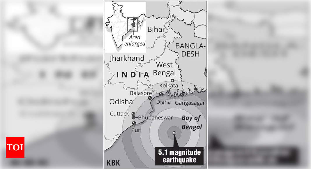
A recent 5.1-magnitude earthquake off the eastern coast of India has sparked concern among scientists, prompting investigations into a potentially undetected fault system beneath the Bay of Bengal. The earthquake, which occurred at a depth of 91 kilometers and was centered approximately 286 kilometers from Puri, sent tremors across Odisha, West Bengal, and Bangladesh, causing widespread alarm. While the magnitude of the earthquake was relatively moderate, its unusual location and depth have raised questions about the seismic stability of the region and the potential for future, more significant seismic events. This essay will delve into the details of the earthquake, the concerns of scientists, and the ongoing efforts to understand the underlying geological factors contributing to this unusual seismic activity. It will further discuss the potential implications for coastal communities in the region and the need for improved monitoring and preparedness measures. The earthquake's unusual nature stems from its location, which is not typically associated with significant seismic activity. Most earthquakes occur along tectonic plate boundaries, where the Earth's lithosphere is divided into large, moving plates that interact with each other. These interactions, such as subduction, collision, and transform faulting, generate immense stresses that can lead to earthquakes. The Bay of Bengal, however, is located relatively far from major plate boundaries, leading scientists to suspect the presence of a previously unknown or poorly understood fault system within the Indian Ocean plate. The depth of the earthquake, at 91 kilometers, also contributes to the mystery. While earthquakes can occur at various depths, those originating at such depths often involve complex geological processes and can have broader regional impacts. The combination of the unusual location and depth has prompted scientists to launch detailed investigations to understand the underlying causes of the earthquake and assess the potential for future seismic activity in the region. Several research institutions and geological survey organizations are involved in the investigation. The Geological Survey of India (GSI) has dispatched teams from Odisha and West Bengal to conduct field studies in the coastal areas affected by the earthquake. These teams will collect data on ground deformation, soil conditions, and other geological features to gain insights into the fault system responsible for the earthquake. The Indian National Center for Ocean Information Services (INCOIS) in Hyderabad, which operates the Tsunami Early Warning Centre, is also conducting studies to assess the potential for tsunamis triggered by future earthquakes in the Bay of Bengal. The CSIR-National Geophysical Research Institute (NGRI) in Hyderabad is contributing expertise in geophysics and seismic data analysis to the investigation. The collaborative efforts of these institutions are crucial for developing a comprehensive understanding of the region's seismic hazards. Initial findings from the investigations suggest the presence of a minor fault system beneath the Bay of Bengal. This fault system may be related to the complex geological history of the Indian Ocean, which has undergone significant deformation and tectonic adjustments over millions of years. The collision of the Indian plate with the Eurasian plate, which formed the Himalayas, has also exerted stresses on the surrounding regions, potentially contributing to the development of faults and fractures in the oceanic crust. The exact nature and extent of the fault system beneath the Bay of Bengal remain uncertain, and further research is needed to map its geometry, assess its activity levels, and determine its potential for generating larger earthquakes. The implications of this unusual seismic activity for coastal communities in the region are significant. The Bay of Bengal is a densely populated area, with millions of people living in low-lying coastal areas that are vulnerable to earthquakes and tsunamis. A major earthquake in the region could cause widespread damage to infrastructure, disrupt essential services, and result in significant loss of life. The potential for tsunamis is a particularly concerning aspect, as the Bay of Bengal is known to be susceptible to these devastating waves. The 2004 Indian Ocean tsunami, which was triggered by a massive earthquake off the coast of Sumatra, caused immense destruction and loss of life in coastal communities around the Bay of Bengal. The recent earthquake serves as a reminder of the region's vulnerability to seismic hazards and the importance of preparedness measures. Strengthening infrastructure, improving early warning systems, and educating the public about earthquake safety are crucial steps for mitigating the risks associated with seismic activity. In addition to the immediate risks posed by earthquakes and tsunamis, the unusual seismic activity in the Bay of Bengal also raises long-term concerns about the stability of the region's coastline. Earthquakes can trigger landslides, ground subsidence, and other geological processes that can alter coastal landforms and increase the vulnerability of coastal communities to erosion and flooding. Climate change is also exacerbating these risks, as sea levels are rising and storms are becoming more intense. The combination of seismic activity and climate change poses a significant threat to the long-term sustainability of coastal communities in the Bay of Bengal. Addressing these challenges requires a holistic approach that integrates geological research, disaster management, and climate adaptation strategies. Improved monitoring and research efforts are essential for understanding the complex interplay of geological and environmental factors that contribute to seismic hazards in the region. Early warning systems need to be strengthened to provide timely alerts to coastal communities in the event of an earthquake or tsunami. Infrastructure needs to be designed and constructed to withstand seismic forces and climate change impacts. Public education campaigns are needed to raise awareness about earthquake safety and promote preparedness measures. International collaboration is also crucial, as the Bay of Bengal is a shared resource that requires coordinated efforts to manage its risks. The countries bordering the Bay of Bengal need to work together to share data, develop best practices, and coordinate disaster response efforts. The recent earthquake in the Bay of Bengal is a wake-up call that highlights the need for greater attention to seismic hazards in the region. By investing in research, preparedness, and adaptation measures, it is possible to reduce the risks associated with earthquakes and tsunamis and protect coastal communities from these devastating events. The scientific community, governments, and local communities must work together to build a more resilient and sustainable future for the Bay of Bengal region.
Building upon the initial assessments and observations, scientists are now employing advanced techniques to scrutinize the geophysical characteristics of the Bay of Bengal. High-resolution seismic surveys are being conducted to map the subsurface structures in detail, revealing the intricate network of faults and fractures that crisscross the region. These surveys utilize specialized equipment to generate and record seismic waves, which are then analyzed to create three-dimensional images of the Earth's interior. The resulting data provides crucial insights into the geometry, orientation, and connectivity of the fault system beneath the Bay of Bengal. In addition to seismic surveys, researchers are also deploying ocean-bottom seismometers (OBSs) to monitor seismic activity directly on the seafloor. OBSs are highly sensitive instruments that can detect even small earthquakes that might go unnoticed by land-based seismometers. By deploying a network of OBSs across the Bay of Bengal, scientists can obtain a more complete picture of the region's seismicity and identify areas of particular concern. The data collected from OBSs is also being used to refine earthquake location estimates and improve the accuracy of seismic hazard assessments. Furthermore, satellite-based geodetic techniques are being employed to measure ground deformation and assess the stability of the coastline. Interferometric Synthetic Aperture Radar (InSAR) is a powerful tool that uses satellite radar images to detect subtle changes in the Earth's surface. By analyzing InSAR data, scientists can identify areas that are undergoing uplift, subsidence, or horizontal movement, which can provide clues about the underlying tectonic processes. These measurements are particularly important for assessing the potential for landslides and other geological hazards along the Bay of Bengal coastline. Complementing these geophysical investigations are studies focused on the region's geological history. Scientists are collecting and analyzing sediment cores from the seafloor to reconstruct past climate changes, sea-level variations, and earthquake events. These sediment cores contain a wealth of information about the region's past environment and can help scientists understand the long-term patterns of seismic activity. For example, the presence of turbidites, which are deposits of sediment transported by underwater currents, can indicate past earthquake-triggered landslides. Similarly, the analysis of microfossils and other biological remains in the sediment cores can provide insights into past sea-level changes and the vulnerability of coastal ecosystems. The integration of geophysical and geological data is crucial for developing a comprehensive understanding of the Bay of Bengal's seismic hazards. By combining the insights from these different sources, scientists can create more accurate models of the region's fault system, assess the potential for future earthquakes, and develop effective strategies for mitigating the risks. The ongoing research efforts are also focused on improving earthquake early warning systems. These systems rely on a network of seismometers and communication technologies to detect earthquakes and issue alerts to coastal communities before the arrival of strong shaking or a tsunami. The existing early warning systems in the Bay of Bengal region are being upgraded with more sensitive sensors, faster communication networks, and more sophisticated algorithms for detecting and characterizing earthquakes. The goal is to provide more timely and accurate warnings to coastal communities, giving them more time to evacuate and prepare for potential hazards. The development of community-based disaster preparedness programs is also a key component of risk reduction efforts. These programs involve training local residents on earthquake safety measures, developing evacuation plans, and establishing emergency shelters. By empowering communities to take action and prepare for potential disasters, it is possible to reduce the impact of earthquakes and tsunamis. The scientific community is also working to communicate the findings of their research to policymakers, government officials, and the general public. Public awareness campaigns are being conducted to educate people about the risks of earthquakes and tsunamis and promote preparedness measures. These campaigns emphasize the importance of having an emergency plan, knowing the evacuation routes, and having a supply kit ready in case of a disaster. The ongoing research and risk reduction efforts in the Bay of Bengal region are essential for protecting coastal communities from the devastating effects of earthquakes and tsunamis. By investing in science, technology, and community preparedness, it is possible to build a more resilient and sustainable future for the region.
The collaborative efforts of national and international research institutions are proving invaluable in unraveling the complexities of the Bay of Bengal's seismic landscape. Shared data, joint research projects, and the exchange of expertise are accelerating the pace of discovery and enhancing the accuracy of hazard assessments. International collaborations also facilitate access to cutting-edge technologies and specialized equipment that may not be readily available in all countries within the region. For example, the deployment of ocean-bottom seismometers often requires specialized vessels and expertise, which can be provided through international partnerships. Similarly, the analysis of satellite-based geodetic data requires sophisticated software and algorithms, which may be developed and shared by international research teams. The benefits of international collaboration extend beyond scientific research. Joint training programs and capacity-building initiatives are helping to develop a new generation of seismologists, engineers, and disaster management professionals in the region. These programs provide opportunities for researchers from different countries to work together, share knowledge, and learn from each other's experiences. This collaboration fosters a sense of shared responsibility and promotes the development of sustainable solutions for managing seismic risks. The effectiveness of disaster management efforts also depends on strong coordination among government agencies, non-governmental organizations, and local communities. A well-defined command structure and clear communication protocols are essential for ensuring a rapid and efficient response in the event of an earthquake or tsunami. Regular drills and exercises are conducted to test the preparedness of emergency responders and identify areas for improvement. These exercises simulate various scenarios, such as a major earthquake or a tsunami inundation, and involve the participation of all relevant stakeholders. The lessons learned from these exercises are used to refine disaster management plans and improve coordination among different agencies. Public education campaigns play a vital role in promoting preparedness and reducing vulnerability to seismic hazards. These campaigns use a variety of media, including television, radio, newspapers, and social media, to disseminate information about earthquake safety and tsunami awareness. The messages are tailored to different audiences and cultural contexts to ensure that they are easily understood and remembered. The campaigns emphasize the importance of having an emergency plan, knowing the evacuation routes, and having a supply kit ready in case of a disaster. Community-based organizations also play a crucial role in promoting preparedness and raising awareness at the local level. These organizations often work directly with vulnerable communities to develop tailored disaster management plans and provide training on earthquake safety measures. They also serve as a trusted source of information and support for local residents. The long-term sustainability of risk reduction efforts depends on the integration of disaster risk management into development planning. This involves considering the potential impacts of earthquakes and tsunamis in all development projects, such as the construction of infrastructure, the siting of settlements, and the management of coastal resources. By incorporating disaster risk considerations into development planning, it is possible to reduce the vulnerability of communities and ensure that development projects are resilient to seismic hazards. The ongoing efforts to understand and mitigate seismic risks in the Bay of Bengal region are a testament to the power of science, collaboration, and community engagement. By continuing to invest in research, preparedness, and development planning, it is possible to build a more resilient and sustainable future for the region, where communities are better protected from the devastating effects of earthquakes and tsunamis. The unusual deep-sea earthquake serves as a crucial reminder of the dynamic nature of our planet and the importance of ongoing vigilance in the face of natural hazards.
Source: Unusual deep-sea quake in Bay of Bengal worries scientists, probe underway