 |
|
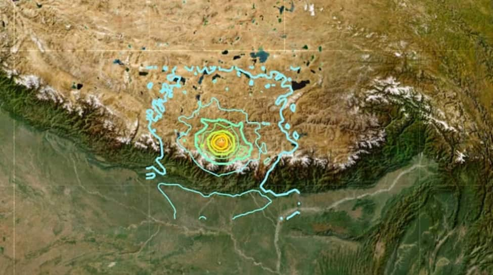
The January 7, 2025 earthquake in Tibet, registering a magnitude of 7.1 on the USGS scale and 6.8 according to Chinese authorities, serves as a stark reminder of the immense geological forces shaping our planet. The epicenter, located in Tingri County, approximately 80 kilometers from Mount Everest, and the relatively shallow depth of 10 kilometers, significantly amplified the destructive power of the tremors. This resulted in widespread devastation across a large region, including Tibet, Nepal, Bhutan, and northern India. The immediate impact was catastrophic, with at least 90 fatalities reported and over 130 injuries. Numerous buildings collapsed in Shigatse and surrounding towns, leaving countless individuals trapped under the rubble. Rescue operations, involving more than 1,500 emergency workers, were immediately launched, focusing on locating and rescuing survivors amidst the chaos and the constant threat of aftershocks.
The geological context of this devastating event lies in the ongoing collision between the Indian and Eurasian tectonic plates. This colossal collision, a process that has been underway for millions of years, is the very force responsible for the formation of the majestic Himalayan mountain range. The region, characterized by its intense geological activity, is inherently susceptible to powerful earthquakes. The specific cause of the January 7th quake was identified as a rupture within the Lhasa block, a significant geological formation situated within the complex tectonic landscape. This block, sandwiched between the Qiangtang and Tethyan Himalayan terranes, endures immense pressure from both north-south compression and west-east stress, a direct consequence of the ongoing Indian-Eurasian plate convergence. These opposing forces lead to substantial crustal uplift, significant lateral movements of the Earth's crust, and the subsequent seismic activity that continues to shape the Himalayas.
The earthquake's impact extended far beyond the immediate epicenter. Strong tremors were felt in Kathmandu, Nepal, located approximately 400 kilometers away. While initial reports indicated no immediate casualties in Kathmandu, authorities initiated thorough assessments to evaluate the extent of damage to infrastructure and buildings. The event prompted widespread fear and panic, leading many residents to evacuate their homes. The global community responded swiftly to the disaster. Chinese President Xi Jinping issued a call for immediate and decisive action to minimize casualties and provide comprehensive support to affected families. International aid organizations also mobilized resources, coordinating relief efforts with local authorities to provide essential aid, including food, water, medical supplies, and temporary shelter. The challenge of providing aid was amplified by the continuing aftershocks, which further destabilized already damaged structures and hampered rescue efforts.
The January 7th earthquake serves as a potent reminder of the powerful and unpredictable nature of geological forces. The Himalayas, a breathtaking testament to the Earth's dynamic processes, are also a region of significant risk. While scientific understanding of plate tectonics allows for predictions of earthquake-prone zones, pinpointing the precise time and magnitude of an earthquake remains an immense challenge. This event underscores the critical need for continued research into earthquake prediction and mitigation strategies. Furthermore, it highlights the importance of robust infrastructure design and building codes in regions highly susceptible to seismic activity. Investing in resilient infrastructure and well-trained emergency response teams is crucial for minimizing the devastating consequences of future earthquakes. The international cooperation demonstrated in the aftermath of this event exemplifies the global commitment to disaster relief and underscores the interconnectedness of the world's communities in the face of shared challenges.
The ongoing research into the specific mechanisms of this earthquake will undoubtedly shed further light on the complex interplay of forces within the Lhasa block and its wider tectonic setting. Detailed analysis of seismic data, geological surveys, and remote sensing data will contribute to a more nuanced understanding of the earthquake's genesis and its long-term implications for the Himalayan region. This knowledge, in turn, will inform future strategies for earthquake preparedness, mitigation, and disaster response. The event also serves as a sobering reminder of the need for continuous monitoring of seismic activity in regions like Tibet, allowing for the timely dissemination of early warning systems and the implementation of effective evacuation protocols. The tragic loss of life and the widespread destruction caused by the earthquake necessitate a renewed global commitment to reducing the vulnerability of communities to the devastating impacts of natural disasters.
Source: Tibet Earthquake: How Lhasa Block's Tectonic Churn Triggered 7.1 Magnitude Tremors
