 |
|
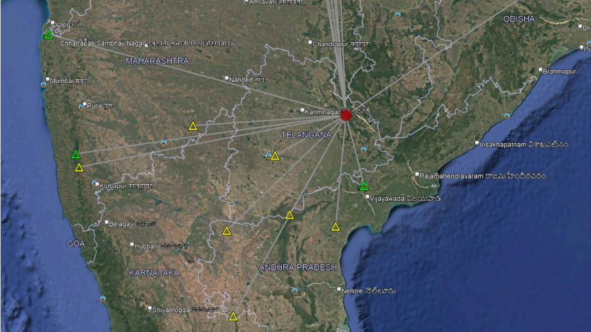
The recent earthquake that struck Telangana on December 4th, 2024, serves as a potent reminder of the geological forces shaping our world. The 5.0 magnitude quake, centered near Medaram in Mulugu district, approximately 250 kilometers from Hyderabad, was significant not just for its intensity, but also for its historical context. Scientists at the CSIR-National Geophysical Research Institute (NGRI) have classified this event as the second largest earthquake recorded in the region in the last 55 years, surpassed only by a 5.7 magnitude quake in Bhadrachalam in 1969. This places the event firmly within the realm of moderate earthquakes, a designation that, while signifying considerable seismic activity, reassures the public that the event did not pose an immediate catastrophic threat. The relatively low level of damage reported further underscores this assessment. While tremors were felt across a wide area, extending more than 200 kilometers to the twin cities of Hyderabad and Secunderabad, the lack of widespread destruction speaks to the resilience of infrastructure in the region and the nature of the earthquake itself.
The NGRI's assessment of the earthquake’s significance is grounded in a comprehensive understanding of the region's geological history and ongoing seismic activity. Director Prakash Kumar's explanation points to the Godavari Rift Basin as the primary culprit. This basin is characterized by a complex network of fractures and faults along the Godavari and Krishna rivers and their surrounding areas. These geological features create zones of weakness in the Earth's crust, making them susceptible to seismic activity. The specific rock formations and their density within the basin also play a crucial role in the propagation of seismic waves. The fact that tremors were felt at considerable distances from the epicenter is directly attributable to these geological factors, emphasizing the importance of considering geological context when assessing the impact of an earthquake. The NGRI's ongoing monitoring efforts, utilizing a network of seismometers, are instrumental in understanding these complexities and predicting future seismic events.
The NGRI's role in this context extends beyond simply reacting to events. The institute, established in 1961, dedicates itself to multifaceted research in Earth system processes. Their work encompasses earthquake hazards, geodynamics, and the exploration of geo-resources. This holistic approach underscores the importance of integrated research in understanding and mitigating the risks associated with geological hazards. The detailed analysis of seismic events like the recent earthquake in Mulugu contributes to a broader understanding of the region's tectonic behavior. This knowledge is crucial for developing more accurate risk assessments, improving building codes and disaster preparedness measures, and ultimately ensuring the safety and security of the communities in the region. The NGRI's commitment to continuous monitoring and research is essential for providing timely information to the public and informing long-term strategies for managing the risks associated with earthquakes in the Godavari Rift Basin.
Furthermore, the incident highlights the need for public awareness and education regarding earthquake preparedness. While the NGRI has rightly downplayed the immediate threat posed by this specific event, the potential for future seismic activity in the Godavari Rift Basin remains. Educational initiatives aimed at informing the public about earthquake safety measures, such as securing homes against potential damage, developing evacuation plans, and establishing communication protocols, are crucial components of broader risk reduction strategies. Such measures are particularly critical in densely populated areas that may be more vulnerable to the effects of an earthquake, even a moderate one. These initiatives should not only focus on the immediate actions to take during an earthquake but also on the broader aspects of community resilience and preparedness in the face of future seismic events.
In conclusion, the 5.0 magnitude earthquake in Telangana underscores the ongoing geological activity within the Godavari Rift Basin and serves as a timely reminder of the importance of continuous monitoring, scientific research, and community preparedness in mitigating the potential risks associated with seismic events. While the recent earthquake was relatively moderate, it highlights the dynamic nature of the region's geology and the need for sustained efforts to understand and adapt to the challenges posed by earthquake hazards. The NGRI's role in this regard is critical, not only in providing timely information and analysis but also in fostering a culture of scientific understanding and community preparedness that will contribute to the long-term safety and well-being of the people living in earthquake-prone areas.
Source: Telangana’s Mulugu ‘moderate’ earthquake second biggest recorded in the region in last 55 years
