
 |
|
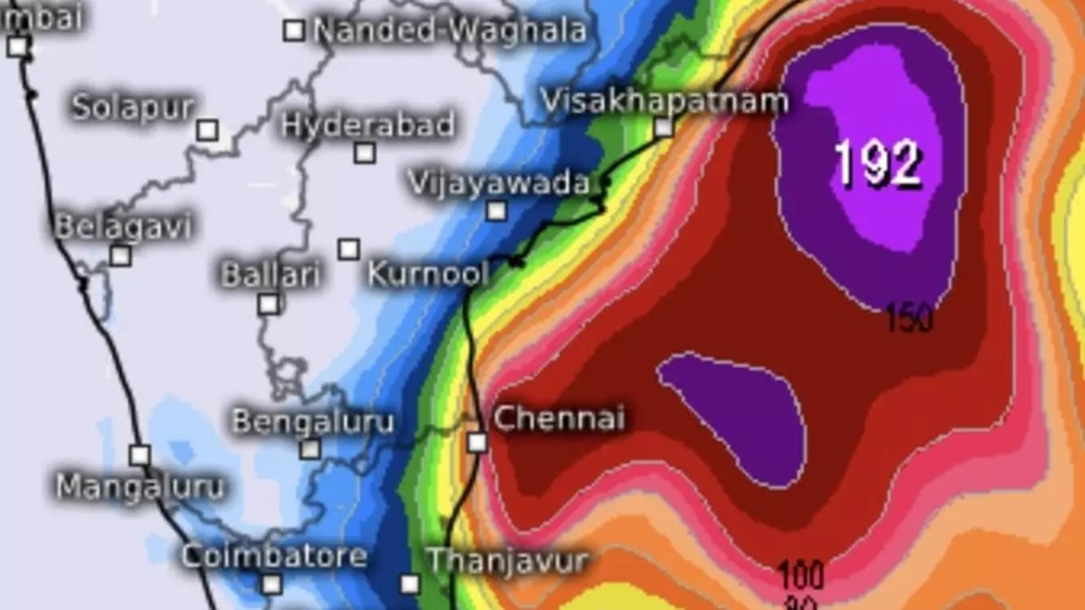
The India Meteorological Department (IMD) has issued a forecast predicting heavy rainfall across parts of Tamil Nadu and Andhra Pradesh. This weather event is primarily attributed to a low-pressure area forming over the southwest Bay of Bengal. The approaching low-pressure system is expected to gradually weaken as it moves closer to the coast, but not before delivering significant precipitation. The IMD's outlook indicates that the system's impact will vary along the coastline, with some areas experiencing heavier downpours than others. The slowing of the low-pressure area in its final approach to land is a key factor in determining the intensity and distribution of rainfall.
A crucial element influencing this weather system's trajectory and intensity is a western disturbance currently positioned over southeast Pakistan. This western disturbance, described as a stationary trough, shows little movement as of Tuesday morning, with its path possibly leading towards southwest Rajasthan. Intriguingly, the proximity of this western disturbance to the North Arabian Sea has triggered the development of a smaller cyclonic circulation over north Rajasthan. This secondary circulation enhances the western disturbance's activity, potentially leading to increased snowfall and rainfall in the northwestern regions of India. The interaction between the western disturbance and the low-pressure area over the Bay of Bengal is complex. Global weather models suggest that the westerlies associated with the western disturbance will alter the low-pressure area's movement, shifting its direction from northwest to northeast.
The IMD's detailed forecast projects isolated heavy rain for Tamil Nadu and Rayalaseema on Wednesday and Thursday. Furthermore, isolated very heavy rainfall is anticipated for Tamil Nadu on Wednesday. Coastal Andhra Pradesh is expected to experience isolated heavy to very heavy rainfall on both Tuesday and Wednesday, with isolated heavy rainfall predicted for Friday. Lighter precipitation, including light to moderate rain along with isolated thunderstorms and lightning, is likely over Tamil Nadu and Puducherry for three days (until Friday), over Coastal Andhra Pradesh and Yanam until Saturday, over Rayalaseema for two days, and in Odisha on Thursday and Friday. The back-to-back nature of these disturbances – the low-pressure area and the western disturbance – could result in a shift in weather patterns, from predominantly wet to potentially cold, depending on the combined intensity and moisture content of these systems. The interplay between these weather systems highlights the complexities of regional weather forecasting and the importance of considering large-scale atmospheric dynamics.
The IMD's forecast underscores the potential for significant disruption to daily life in the affected areas. Heavy rainfall can lead to flooding, landslides, and transportation disruptions, requiring preparedness and proactive measures from local authorities and residents. The timing of the rainfall, coinciding with the ongoing winter season, further emphasizes the need for caution, as colder temperatures can exacerbate the impact of heavy rain. Accurate and timely weather information is crucial for effective disaster preparedness and mitigation. The IMD's continuous monitoring and detailed forecasts play a vital role in enabling communities to adapt and respond to the challenges posed by these upcoming weather events. The potential for widespread disruption necessitates a coordinated response from relevant agencies to ensure public safety and minimize the negative consequences of the anticipated heavy rainfall.
The interplay between the low-pressure system and the western disturbance represents a classic example of how large-scale atmospheric patterns can significantly impact regional weather. Understanding these interactions is crucial not only for accurate short-term forecasting but also for improving long-term climate prediction and mitigation strategies. Continued monitoring of both systems is crucial to refine the forecast and provide more precise information to the affected communities. Further research into the complexities of these interactions could lead to improvements in weather prediction models, allowing for more accurate and timely warnings in the future. The potential for cascading effects, such as flooding and landslides, necessitates a comprehensive approach to disaster preparedness, encompassing public awareness campaigns, early warning systems, and effective emergency response protocols.
Source: IMD Update: Heavy rain likely over TN as ‘low’ moves towards coast